A wreck with tales to tell at Naikoon, Haida Gwaii. The islands have gone by many names. To the people who call the islands home, Haida Gwaii means “island of the people,” it is a shortened version of an earlier name, Haadala Gwaii-ai, or “taken out of concealment.”
Back at the time of Nangkilslas, it was called Didakwaa Gwaii, or “shoreward country.” By any name, the islands are a place of rugged beauty and spirit and enjoy a special place in both the natural and supernatural world. The enormous difference between high and low tide in Haida Gwaii – up to twenty three vertical feet – means that twice a day, vast swathes of shellfish are unveiled, free for the taking.
An ancient Haida saying is still often heard today, “When the tide is out, the table is set.” Archaeological evidence shows that by about five thousand years ago, gathering shellfish replaced hunting and fishing as their primary food source. The shellfish meat was skewered on sticks, smoked and stored for use in winter or for travel.
Steeped in mist and mythology, the islands of Haida Gwaii abound in local lore that surrounds their beginnings. Today, the Hecate Strait is a tempestuous 40-mile wide channel that separates the mist-shrouded archipelago of Haida Gwaii from the BC mainland. Haida oral tradition tells of a time when the strait was mostly dry, dotted here and there with lakes. During the last ice age, glaciers locked up so much water that the sea level was hundreds of feet lower than it is today. Soil samples from the sea floor contain wood, pollen, and other terrestrial plant materials that tell of a tundra-like environment.
The islands of Haida Gwaii are at the western edge of the continental shelf and form part of Wrangellia, an exotic terrane of former island arcs, which also includes Vancouver Island, parts of western mainland British Columbia and southern Alaska.
 |
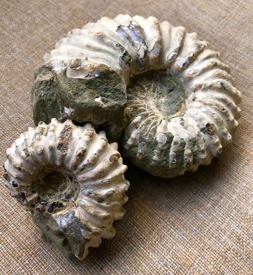
Brewericeras hulenense (Anderson, 1938)
|
While we’ll see that there are two competing schools of thought on Wrangellia’s more recent history, both sides agree that many of the rocks, and the fossils they contain, were laid down somewhere near the equator.
They had a long, arduous journey, first being pushed by advancing plates, then being uplifted, intruded, folded, and finally thrust up again. It’s reminiscent of how pastry is balled up, kneaded over and over, finally rolled out, then the process is repeated again.
This violent history applies to most of the rock that makes up the Insular Belt, the outermost edge of the Cordillera. Once in their present location, the rocks that make up the mountains and valleys of this island group were glaciated and eroded to their present form. Despite this tumultuous past, the islands have arguably the best-preserved and most fossil-rich rocks in the Canadian Cordillera, dating from very recent to more than 200 million years old.
The fossils found in the Triassic rock of Wrangellia are equatorial or low latitude life forms quite different from those found today on the Continent at the latitude of Haida Gwaii. This suggests those rocks were in the equatorial region during the Late Triassic, just over 200 million years ago.
The Lower Jurassic ammonite faunas found at Haida Gwaii are very similar to those found in the Eastern Pacific around South America and in the Mediterranean. The strata exposed at Maple Island, Haida Gwaii are stratigraphically higher than the majority of Albian localities in Skidegate Inlet. The macrofossil fauna belonged to the Upper part of the Sandstone Member of the Haida formation.
The western end of the island contains numerous well-preserved inoceramids such as Birostrina concentrica and a few rare ammonites of Desmoceras bearskinese. The eastern shores are home to unusual ammonite fauna in the finer grained sandstones. Here we find the fossils as extremely hard concretions while others were loose in the shale. Species include Anagaudryceras sacya and Tetragonites subtimotheanus. A large whorl section of the rare Ammonoceratites crenucostatus has also been found here. The ammonites, Desmoceras; Brewericeras hulenense; Cleoniceras perezianum, Douvelliceras spiniferum are all found in Lower Cretaceous, Middle Albian, Haida Formation deposits.


.jpg)


